


 Reply With Quote
Another update, this time adding driving directions (Directions tab, search for directions as normal, then click through the 3 buttons). Deniska, the POI is also cleaned up with segmenting the area and checking for duplicates, thanks for spotting that. Also, I am now on ps2dev under the same username.
screenshot:
http://homepage.mac.com/f.levin/psp/gmdl24.jpg
source and exe (in /bin/debug/):
http://homepage.mac.com/f.levin/psp/gmdl24.zip
Pulling down directions works through a very similar way to POIs and generates a POI file with the way-points. This is also through Loval.Live, and they seem to have excellent worldwide coverage.
Once again, I would appreciate any feedback, as I will probably start cleaning up the code next week.
Results 51 to 60 of 1164
-
August 24th, 2006, 19:06 #51DCEmu Newbie


- Join Date
- Aug 2006
- Posts
- 2
- Rep Power
- 0

hi,
i'm a french guy and i have a litle bug whith poi options because on Windows XP french, the lat & lon values are '.' (point) for separate decimal number. I must change the points into commas so that it works.
I hope that will help you.
Sorry for my english.
bye
-
August 24th, 2006, 23:27 #52DCEmu Regular
- Join Date
- Aug 2006
- Posts
- 299
- Rep Power
- 70
-
August 25th, 2006, 00:17 #53PSP User

- Join Date
- Aug 2006
- Location
- gainesville FL
- Posts
- 57
- Rep Power
- 0


dude thsi crap is getting crazy
very nice in7ane
you have made mapthis so much more
keep it up
-
August 25th, 2006, 02:12 #54PSP Coder

- Join Date
- Jul 2005
- Posts
- 1,557
- Rep Power
- 80
 Originally Posted by in7ane
Very nice! you are reading my mind, man!
I was gonna ask you to do directions ;-)
POI works really good now, I was able to pull a few thousands restaurants off a relatively small area (just a few miles)
Well, as always, a few suggestions...
I am rethinking the POI display logic..
want to alocate 38 chars for desscr1 and 60 chars for desrc2. Could you put the comma after the POI name (desrc1) and put the rest (addr/phone) in to descr 2 ?
I want to store waypoints in the same structure as POI on PSP, although I'll probably display them in bigger font.. so I was thinking, it would be best if you could merge everything after the lat/lon in to one line and spit it in to segments (37 & 60 chars long) with a comma.
Second descr field could be longer than 60 - it'll be truncated by PSP.. but there should be a closing comma at the end (ie number of commas on each lime must be 4
The way point file must have:
!WAYPOINT
line, - this way I would know that I need to display it differently....
I'll try to release a new version with improved POIs and some other stuff in a few days...
-
August 25th, 2006, 23:48 #55DCEmu Newbie
- Join Date
- Aug 2006
- Location
- Germany
- Posts
- 12
- Rep Power
- 0
I have an error :
http://img174.imageshack.us/img174/912/aufnahme3py4.jpg
How to fix it?
-
August 27th, 2006, 16:25 #56DCEmu Newbie
- Join Date
- Aug 2006
- Location
- Germany
- Age
- 40
- Posts
- 5
- Rep Power
- 0
Hi!
First I must say that this is a very nice tool, thx to deniska also!!
I think I fund the bug that martial mentioned. The decimal Parser in the function poiList_Click() is culture dependant. I live in Germany and here we have a decimal comma instead of a point, so when I click on the "List" Button, I always get 0 Poi's returned.
By adding Decimal.Parse(poiLatS.Text, NumberFormatInfo.InvariantInfo) the funtion seems to work, so I get Poi's but the Lat/Lon Values in the List don't have a decimal point anymore... I don't have experience with c#, but I hope that it helps a bit.
Another way to fix it is to set English(USA) as default in region and language options in the system settings, but I don't want to do that everytime ...
...
-
August 28th, 2006, 19:51 #57DCEmu Regular
- Join Date
- Aug 2006
- Posts
- 299
- Rep Power
- 70
kAraCHo, thanks for looking into that - that seems to fixed now (this should fix martial's probalems, and maybe also MJ DwaTrzy's - although that also looks like the search terms are not specific enough, try them out in "Driving Directions" on Local.Live first)
Deniska, the program should now comply with the new POI format. For anyone running it in the older version of MapThis! there is a legacy mode option in the top right corner.
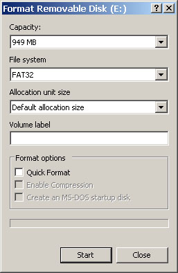
Also, what are the exact instructions for formatting the Memory Stick in Fat32, if somebody could point me in the direction of a screen by screen guide it would be much appreciated - I've tried with a 2GB memory stick duo one and failed. Or is the map container format likely to come soon?
Someone asked about custom maps, as far as I can see it can be done as long as you match up what the numbers would be in Google Maps, the file format is: first horizontal tile index first vertical tile index zoom level (in 1x folder). Also keep in mind that you will need at least the most zoomed out directory with the 4 base tiles. And consider that this will be a lot of work, and is very likely to go wrong somewhere along the way (scale, alignment, order of tiles, etc.) - if you can program/script a graphics package, that would probably be the best approach, and everyone else will benefit as well from another source. Deniska's scripts should be useful, as I recall there is one that converts lon/lat into tile coordinates.
Someone else asked to post maps - don't, you will most definitely be in violation of Google/Microsoft terms of use. Anyway, the requirement is .NET 2 (which will run on anything back to Windows 2000 or so), not XP SP 2. And will install regardless of whether or not you made peace with WGA.
Others may have run into this as well - Google seems to cut you off from downloading satellite imagery after you hit a certain threshold, this lasts a few hours during which time you will get the "imagery not available" message.
Regarding the free BaseMap from Garmin, thanks for the suggestion, but it seems to be in a proprietary format (and probably vector). I would be interested in getting NASA World Wind working first. (Ask and Yahoo are also potential 256x256 compliant sources which would be reasonably easy to implement - if anyone can see them as being better than Google/Local.Live)
To summarize, in this version:
- midpoints in directions
- an attempt at supporting "," decimal points
- new POI format (option to disable in the top right)
- selective levels of detail, the screen will appear for max_zoom - min_zoom > 2 (max maps now 512*512) if the option is checked in advanced - it seems you need the corners for the map to work though
- Yahoo as a POI source, thanks deniska (yes, the mile radius will eventually be automatically calculated)
screenshot:
http://homepage.mac.com/f.levin/psp/gmdl25.jpg
source and exe (in /bin/debug/):
http://homepage.mac.com/f.levin/psp/gmdl25.zip
Deniska, a few questions/requests: Would it be possible to draw lines between waypoints? Satellite (and Local.Live map) imagery goes to below zoom 0, is there a way to implement support for this? And, if you do implement a container format for maps, is it possible to change the file name format to allow for larger maps than 512*512?
-
August 28th, 2006, 20:22 #58DCEmu Newbie
- Join Date
- Aug 2006
- Posts
- 2
- Rep Power
- 0
thanks you very mutch

-
August 28th, 2006, 21:01 #59PSP User
- Join Date
- Aug 2006
- Location
- gainesville FL
- Posts
- 57
- Rep Power
- 0
great work again, im wondering whats the best version of mapthis you found? it seems to mee the odler ones are better the latest one i got from neo had bugs and for some reason my gps didn't work*yes i did the noob checklist, yes my gps worked before* i use the green screened gps stat viewer later today to conferm if its the new mapthis thats not right.
btw when will this be made into single .exe file? *if planed*
-
August 28th, 2006, 21:52 #60PSP Coder
- Join Date
- Jul 2005
- Posts
- 1,557
- Rep Power
- 80
1) Turn On USB mode on you psp and connect the cable. Originally Posted by in7ane
2) Right click on the drive, coresponding to your PSP's mass storage device in "My Computer" section
3)Select "format" option.. you should get this screen:
Thread Information
Users Browsing this Thread
There are currently 1 users browsing this thread. (0 members and 1 guests)

Bookmarks