


 Reply With Quote
Excellent
Can't wait dude
Results 1 to 7 of 7
Thread: New GPS Application - AVEC
-
August 10th, 2009, 14:53 #1PSP Coder


- Join Date
- Nov 2005
- Posts
- 477
- Rep Power
- 0
 New GPS Application - AVEC
Hi Guys,
This is an announcement/teaser type thread for an upcoming release.
It's a vector mapping GPS application for the PSP.
It uses a readily available map format which I'll keep quiet about for now.
Obligatory screenshots:
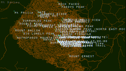
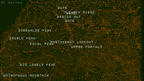
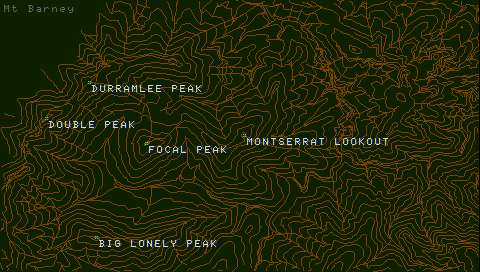
The above screenshots are topography of Mt Barney National Park (Australia).
Street maps are also supported:
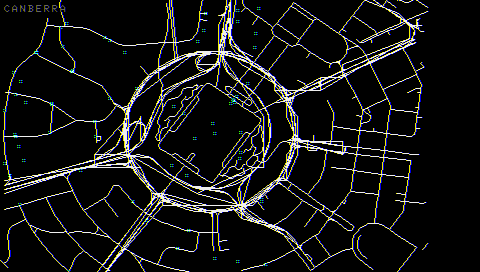
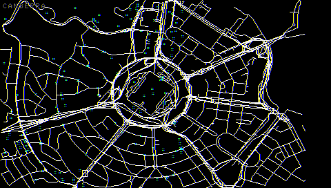
The above are two screenshots above Canberra (Australia) at different zoom levels.
I also hope to have a ??Playable?? demo released very soon with biult in map for testing.
Cheers, Art.Last edited by Art; August 10th, 2009 at 17:34.
-
August 10th, 2009, 15:15 #2PSP User


- Join Date
- Sep 2007
- Location
- UK-England-Walsall
- Age
- 37
- Posts
- 484
- Rep Power
- 0


-
August 10th, 2009, 20:43 #3DCEmu Rookie

- Join Date
- Jun 2005
- Age
- 46
- Posts
- 162
- Rep Power
- 74
Go on!
-
August 11th, 2009, 08:48 #4DCEmu Newbie

- Join Date
- Jan 2006
- Posts
- 76
- Rep Power
- 0
Awsome mate.. I hope u have Waypoints So we can record a path and then follow that path next time we want to go there.. Eg. fishing spots..
Looking forward to testing this out..
-
August 11th, 2009, 10:06 #5PSP Coder
- Join Date
- Nov 2005
- Posts
- 477
- Rep Power
- 0
Hi,
yes track logs will be implemented after the demo release.
-
August 11th, 2009, 13:49 #6DCEmu Newbie
- Join Date
- Jan 2006
- Posts
- 76
- Rep Power
- 0
Thats Great news mate... Originally Posted by Art

oi oi oi Aussie Aussie Aussie
Ps.. if you need any testing done let me know..
-
August 11th, 2009, 14:12 #7PSP Coder
- Join Date
- Nov 2005
- Posts
- 477
- Rep Power
- 0
The demo is up in the other thread to play with.
You might recognise Canberra then, but there are problems with the free Canberra map file
which result in some box lines being drawn.
I couldn't include the Garmin City Navigator Copyrighted map used in the video.
Thread Information
Users Browsing this Thread
There are currently 1 users browsing this thread. (0 members and 1 guests)
Similar Threads
-
Introversion job offer for prototyping Mobile Defcon
By yaustar in forum Sony Consoles News ForumReplies: 10Last Post: May 27th, 2007, 01:21

Bookmarks