


 Reply With Quote
is there a tutorial on loading waypoints/poi onto psp from in7ane's windows program, I'm not sure how to.
Results 101 to 110 of 118
Thread: Map This! v0.2
-
September 12th, 2006, 20:36 #101PSP Coder


- Join Date
- Jul 2005
- Posts
- 1,557
- Rep Power
- 80
 SDL_SOUND was put in before the GPS functions...
 Originally Posted by ZeroAltitude
For some reason it does not work in kernel mode and GPS would not function in user mode.. so I used SDL_SOUND as a switch... I did not care about the sound so much, since it needs to be shut off in order for GPS to function (plug in to power the serial port)
So don't set the SDL_SOUND if you need the GPS functionality...
I don't think this would be your problem if you uses my original EBOOTS...
-
September 12th, 2006, 22:38 #102DCEmu Newbie
- Join Date
- Feb 2006
- Posts
- 59
- Rep Power
- 0
-
September 12th, 2006, 22:40 #103DCEmu Newbie
- Join Date
- Sep 2006
- Posts
- 15
- Rep Power
- 0
Hi Deniska,
I apologize I was not clear in my earlier post. Let me try one more time.
I have a 4800 baud GPS. In MapThis, there is nowhere where you call setBaud() anymore -- the only place in there is inside an ifdef for SDL_SOUND.
Are you saying that in your latest release, the setBaud() call *is* being made, but not inside an ifdef? Do you have any pointers as to the appropriate setting for READTIME for a 4800 baud GPS?
Again, thanks in advance. I find the code fairly easy to learn, so if you have any place where you're maintaining a buglist or something where I could take a look and offer some patches for your approval, I'd be delighted.
~0
-
September 12th, 2006, 22:58 #104PSP Coder
- Join Date
- Jul 2005
- Posts
- 1,557
- Rep Power
- 80
It's ifNdef ;-)
i.e if SDL_SOUND is not defined then you set the baud...
Image * cursor, *blank, *scale, *zoomscale, *arrows, *compass;
#ifndef SDL_SOUND
pspDebugSioInit();
pspDebugSioSetBaud(baud);
pspSdkLoadInetModules();
#endif
-
September 13th, 2006, 01:10 #105DCEmu Newbie
- Join Date
- Sep 2006
- Posts
- 3
- Rep Power
- 0
For some reason I cannot send you a private message (forbidden?!). So I sent an email to the teamjak dot net domain. If that does not work out maybe you can contact me privately. Regarding the zoom: here the gps coordinates change depending on the zoom level... and it is really a 0.5 degrees change in LAT ... Originally Posted by deniska
-
September 13th, 2006, 01:31 #106DCEmu Newbie
- Join Date
- Sep 2006
- Posts
- 15
- Rep Power
- 0
Ack whoops, my bad. Trying tonight with settings 4 - 8 for READTIME with Sept 8 expanded buffer distro.
~0
-
September 13th, 2006, 06:00 #107DCEmu Newbie
- Join Date
- Sep 2006
- Posts
- 15
- Rep Power
- 0
Many apologies for the long post.
Hello,
Thank you for bearing with me. I feel like I'm almost there. With READTIME set to 8, here is what happens in MapThis:
* I get the correct number of satellites
* I get the time
* Where it says the data status, I get DATA: BAD
* In local maps of my home town, I get occasional messages that the location is out of range
* When I switch to the global map to see what location it might be, it's 0.0000 lat -0.50000 long or something very similar (an obvious data error)
Now, mind you, in greenscreen, I get reasonably accurate listings of my latitude and longitude (I see the sentences with the data from my Garmin, and the numbers above reflect them fairly closely).
My questions:
* how can I provide you with any data you might need to figure out this problem?
* could this old GPS be using an incompatible NMEA sentence format? (I would have assumed that if the problem were this, then greenscreen would also fail to parse these sentences...)
A puzzling thing I've noticed -- in Deniska's original greenscreen photo from early on, the data listed in the NMEA sentences for lat. and long. appear to be ever so slightly different from what's displayed above in lat. and long. (to be specific:
from http://www.dcemu.co.uk/vbulletin/showthread.php?t=30035
from upper portion: lat: 40.169..., long: -73.970...
from NMEA sentences: $GPRMC,034123.000,A,4037.1983,07538.2213...
Note the last two sentence numbers look uncannily similar to the Lat. and Long. -- I don't know the NMEA spec well, but I was just curious about how to iinterpret these numbers. In particular, I noticed on my Garmin it would say e.g. lat 42.00 etc., and in the NMEA sentence in the bottom of greenscreen, it would have numbers that were *just like* 42.00 etc., while similar to Deniska's screenshot, the upper numbers were slightly different. Just curious as to how that all works.
Anyway, I'm really looking forward to using MapThis. I'm sorry this message is so long. I'm just trying to provide as much info as I can.
~0
-
September 13th, 2006, 10:52 #108DCEmu Newbie
- Join Date
- Aug 2006
- Posts
- 14
- Rep Power
- 0
Hi folks, it's me again. My results from the newest beta:
Readtime 1:
Nothing
Readime 2:
Almost works. When I hit [] it waits for 1 second, then it moves from where I am now (south norway) to the top of norway in 0.5 seconds, and it locks on my correct position. After that, it updates with the (possible correct) position each 50 second. Also, everything in the program updates every 2 seconds.
-
September 13th, 2006, 14:45 #109DCEmu Newbie
- Join Date
- Feb 2006
- Posts
- 59
- Rep Power
- 0
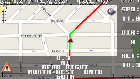
how do you get that line to show up? all i see are squares on every turn, but i dont get that red line.
-
September 13th, 2006, 18:02 #110PSP Coder
- Join Date
- Jul 2005
- Posts
- 1,557
- Rep Power
- 80
in7ane's tool has an option to configure the total number of way points. In my example, it's just so many of them that they touch eachother, creating a line.. I'll try to work out a better solution in future releases...
Thread Information
Users Browsing this Thread
There are currently 1 users browsing this thread. (0 members and 1 guests)

Bookmarks